|
Generation10 TM Image Generators
with BlueSky TM Real-Time Software
|
|
|
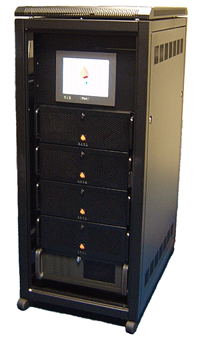
Incorporating multiple CPU and GPU processing cores, the latest Generation10 TM Image Generators from Equipe
offer the highest 'polygon per dollar' count in their class.
Taking full advantage of leading-edge graphics technologies,
Equipe G10 TM with BlueSky TM delivers uncompromising performance and features to power the most demanding of
simulation applications.
System Architecture
Up to 64 hardware gen-locked channels
Up to 4GB system memory
Up to 1GB graphics memory
Programmer's API for customisations
Multiple Independent Views
Overload management
Control Center runs on remote Windows PC
Vehicle route record & playback
Round Earth terrain system using WGS84 datum
Ethernet, reflective memory and other host interfaces
Pixel-based non-linear mapping (ProMapTM) built-in option
Touch panel operation & diagnostics
|
Performance
Rock Solid 60Hz Update Rate
54 billion textured pixels per second (peak) per channel
Full-screen antialiassing, up to 8 sub-samples plus super-samples
Display resolution up to 1920 x 1920 per channel
Exceeds FAA / JAA Level D standards
Fully utilizes latest Shader technologies
Anisotropic texture filtering, up to 16x
|
|
Environmental
Visibility range configurable up to 250 NM
Up to 4 cloud layers, solid or variable patchiness
Wet & snow-covered runways
Automatic snow-covered terrain related to precipitation
3D fluffy clouds, individually controllable
Thunderstorm cell, lightning flash & bolt
Volumetric ground & patchy fog
Light-point glare & halos in fog plus burn through
3D physics-based dynamic ocean for sea states 0 through 9, including whitecaps
|
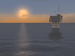 |
3D physics-based dynamic ocean with sun and object reflections |
|
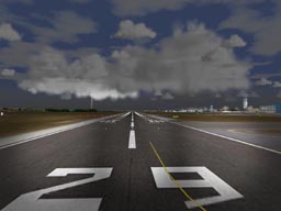 |
Landing lights and storm cell (thunder clouds & lightning bolt) |
|
Lighting
Multiple landing lights, steerable
Airfield lighting systems including VASI, PAPI & strobes
Host-controlled lights & animations
Environmental lights, auto-switching
Continuous time of day and time of year with sun, moon & stars
Dawn & dusk horizon glow
Ultra-realistic floodlighting
|
Database & Models
Continuous multiple LOD terrain
Terrain & texture paging supports very large (continental) geographical areas
Up to 250 moving models, each with articulated parts
Capable of rendering vast numbers of point features (trees, buildings, lights, etc.)
Fully integrated with Equater modelling toolset
|
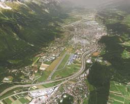 |
Part of Equipe's European Alpine Database |
|
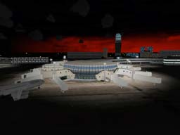 |
Floodlighting and directional horizon glow |
|
Special Effects
Smoke & contrails for aircraft and missiles
3D volumetric animated explosions for air, ground & water
Bump mapping & multi-texturing
Ground shadows of dynamic objects
Fire and wind-driven smoke plumes
Rotor downwash and dust over land & sea
|
Simulator Support
Collision detection
Line of sight and laser range finding
Multiple reference points for Height Above Terrain (HAT) and Height Of Terrain (HOT)
Sensors
Multi-spectral FLIR & NVE (simulated or stimulated)
Manual gain & offset or AGC
Simulated noise (static & dynamic)
Vibration & stabilization
Integrated HUD
|
 |
Infrared option |
|
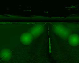 |
Simulated NVE option |
|
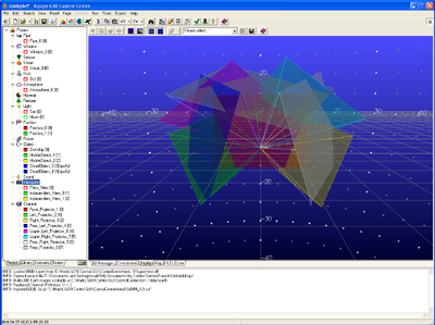 |
Display Configurator on Windows |
|
Control Centre
Provides total control of the IG environment
Powerful and intuitive graphical user interface
Allows user to fully command the system
No complex configuration files
Runs on a standard Windows platform
Connects to G10 via a standard LAN
Comprehensive context-sensitive on-line help
New Project Wizard
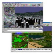
3D Display Configuration
Database Selection
Interactive Moving World Map
Project Verification
Project IG Start/Stop
Environment Control (weather conditions, TOD, etc.)
On-line Control of all entities / properties
User-defined Control Pages for demos, etc.
Import / Export QUIL Scripts
Network Packet Tracing
Round-Earth co-ordinate support
Integrated Basic Flight Model
For more information about Control Centre click here.
|
|
|

|
|
C-series
Cross-Cockpit Collimated displays
|

|
|
|
Generation 10
COTS multi-channel IG with added value and ultra high performance
|

|
|
|
BlueSky
Complete System Integration with BlueSky Visual Real-Time Software
|

|
|
|
ProMap
Enables Projection onto curved screens with mapping, blending and shading
|

|
|
|
Equater
Equater enables large area Geo-specific terrain models to be created in hours
|
|
|
|
Global Projector
Our target projector provides a cost-effective target entity at near eye-limiting resolution
|

|
|
|
 Home
Contact Us
Careers
Copyright © 2018 Equipe Electronics Ltd