|

|
Equater TM for Windows TM
On-Line Demo Movies
|

|
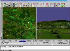
Interactive Terrain Editing
|
Editing a scene from the G10 Dambusters demo.
This movie shows typical fine tuning of a scene,
with the addition of some small features (cows) to a field, and a building being rotated into position.
Equater's powerful interactive editing and viewing facilities enable updates to be viewed in 3D
without the need to regenerate output files, thus enabling the user to rapidly modify and interact with the scene.
This frees up valuable IG time and improves creativity and productivity.
View Movie (4MB)
Back to Top
|
|
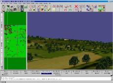
Auto Population
|
Lack of vector data correlated with imagery has traditionally led to individual trees having to be
manually added with the mouse or randomly scattered. Equater uses advanced image recognition
and vectorization techniques to detect significant point, area and linear features in aerial or satellite
imagery. This enables large areas of imagery to be realistically populated in minutes.
The movie starts with a typical featureless countryside scene. A single texture tile is selected and
Equater's feature detector is used to find individual trees in the texture image. The detected trees
are displayed as blue dots on top of the texture. Various parameters are changed to improve detection
before being vectorized to form individual tree point vectors. The same detection parameters are then
applied to all texture tiles making up the scene and the resulting 3D scene is then flown. Finally
Equater's global attribute editor is used to apply a random height to the trees and the resulting
database is flown.
View Movie (2MB)
Back to Top
|
|
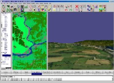
Material Texture and Features
|
This movie shows the generation of textures from 10m monochrome satellite DOI 10m data
obtained from NIMA. The monochrome data has been classified using Equater's Image Classifier. The resulting
classification is then used to "colourise" the monochrome imagery producing a coloured geospecific texture.
The material classification can also be used to "raster paint" assigned material textures to produce
a geotypical texture at a much higher resolution than the original 10m data.
The raster painted areas can then be automatically populated with features.
A single tile is selected and the Process Texture tab displayed. Parameters are entered so that the
black and white texture is cut out from the satellite image at the required resolution and then coloured
using a Material Transfer technique. The resulting coloured texture is displayed.
A second tile is selected and the Raster paint is used along side the Colour transfer method to generate
a texture which is part geospecific and geotypical.
The resulting textured terrain skin is then flown starting over the colourised texture and finishing at
the raster painted area.
Finally features are replicated for the raster painted areas and added to the scene.
This is a powerful technique for rapidly populating large areas of geotypical database
View Movie (6MB)
Back to Top
|
|
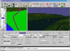
Low Cost Large Area Database
|
Shows the generation of a low cost geotypical database from simple terrain elevation and vector data.
Altitude texture is generated, and the resulting terrain is flown in 3D. The DFAD data is then Vector Painted
on top of the altitude texture and the resulting terrain flown showing the textured lake, forests
and roads. The lake is not flat so the terrain is constrained, rebuilt and displayed. Finally Equater's
Vector clipper is used to cut the road through the forest at the side of the lake. The resulting vectors
and terrain are shown.
View Movie (3MB)
Back to Top
|
|
|

|
|
C-series
Cross-Cockpit Collimated displays
|

|
|
|
Generation 10
COTS multi-channel IG with added value and ultra high performance
|

|
|
|
BlueSky
Complete System Integration with BlueSky Visual Real-Time Software
|

|
|
|
ProMap
Enables Projection onto curved screens with mapping, blending and shading
|

|
|
|
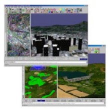
Equater
Equater enables large area Geo-specific terrain models to be created in hours
|
|
|
|
Global Projector
Our target projector provides a cost-effective target entity at near eye-limiting resolution
|

|
|
|

 Home
Contact Us
Careers
Copyright © 2018 Equipe Electronics Ltd
Home
Contact Us
Careers
Copyright © 2018 Equipe Electronics Ltd